Alter the Mini Map displayed in My House
Overview
When displaying the My House page for an address it is usual to add a mini map showing the location of the current address with the Unique Property Reference Number (UPRN). Depending upon how this is configured you can alter the:
- type of map displayed
- information displayed underneath the mini map
- size of the mini map
Step-by-step guide
- Open Studio and expand the My House Map Source and the Layers node underneath.
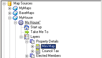
- Either expand the existing Virtual Layer Group for your Mini Map or, to create a new one, right click on the Layers node and select Add Virtual Layer Group and give it a Name e.g. Property Details
- Either select the existing Virtual Layer for your Mini Map or, to create a new one, right click on the Virtual Layer Group and select Add Virtual Layer.
Enter a Layer Name e.g. mini-map.
Alter the Display Name as you wish e.g. Mini Map. If you don't want a name displayed for this virtual layer then enter an underscore here.
You may need to enter more than one underscore if you already have a virtual layer with one underscore.
- The control of the mini-map is handled by the Row Settings, either double click on the existing entry to edit it e.g.
Or click on the green plus to add a new row.
 - Select the Example code from one of the following examples and edit it to suit your requirements.
- Save you changes.
Examples
A specific Map Source for the mini map has to be created under the BaseMaps node. This Map Source has to be a WMS Basemap Type have a URI to the local MapServer i.e. not ADS. Your Astun Consultant would normally create this for you.
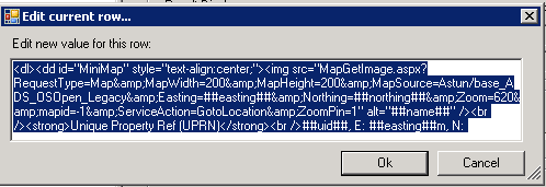
Example 1 showing UPRN & Easting / Northing information
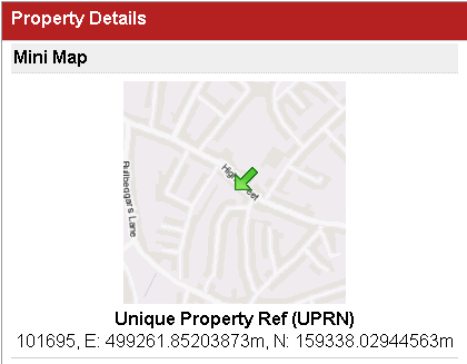
This example has a Display Name defined for the Virtual Layer in Studio.
<dl><dd id="MiniMap" style="text-align:center;"><img src="MapGetImage.aspx?RequestType=Map&MapWidth=200&MapHeight=200&MapSource=Astun/base_ADS_OSOpen_Legacy&Easting=##easting##&Northing=##northing##&Zoom=620&mapid=-1&ServiceAction=GotoLocation&ZoomPin=1" alt="##name##" /><br /><strong>Unique Property Ref (UPRN)</strong><br />##uid##, E: ##easting##m, N: ##northing##m</dd></dl>
To change the size of the map alter the MapWidth and MapHeight entries. To change the map alter the MapSource entry - this is the relative path to the Map Source .xml file without the xml extension.
Lastly you can add what is displayed underneath the map. In the above scenario this is:
<strong>Unique Property Ref (UPRN)</strong><br />##uid##, E: ##easting##m, N: ##northing##m
Here you can also use Virtual Layer tags which will be replaced with the relevant information when the page is displayed.
Example 2 showing Aerial Photography & Copyright
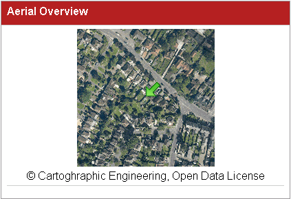
This example does not have a Display Name defined for the Virtual Layer in Studio.
<dl><dd id="MiniMap" style="text-align:center;"><img src="MapGetImage.aspx?RequestType=Map&MapWidth=200&MapHeight=200&MapSource=Astun/base_Aerial_Legacy&Easting=##easting##&Northing=##northing##&Zoom=180&mapid=-1&ServiceAction=GotoLocation&ZoomPin=1" alt="##name##" /><br />© Cartoghraphic Engineering, Open Data License</dd></dl>
In the above example where are using a different MapSource and instead of displaying the Property information we are displaying a copyright statement.