iShare GIS
Overview
iShare GIS offers much of the desktop functionality that most users require, enabling migration from a desktop to the browser solution for the majority of an organisation’s users, including even occasional data editors. iShare GIS will promote the wider use of spatial data within an organisation. It has a scalable architecture that enables an organisation to start off small with the potential to expand with no additional licensing costs.
iShare GIS uses ‘Profiles’ to determine which data and functionality are available to a user, for example one user may have access to limited data, a gazetteer search and printing functionality, while a planning officer may have access to detailed data, several historic base maps, editing, annotation and analysis tools. A user can be assigned more than one profile and has the option to switch between profiles.
iShare GIS delivers ‘Business Intelligence’ across the organisation and its partners linking to corporate data from back office systems or stored within the PostGIS database, which is controlled and shared for both internal users and partners via the iShare Studio application.
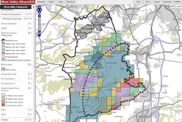
iShare GIS at Mole Valley District Council, displaying planning constraints
iShare GIS standard functionality includes:
- An intuitive Google style interface, navigation and controls
- Layer control that incorporates a legend and enables manual selection
- Ability to restrict functionality by User Roles - All areas of interaction can be defined according to the user’s role.
- A search feature which can be configured to search against NLPG, AddressBase or internal datasets (e.g. assets, planning)
- Selection & Measurement tools (linear and area) and feature info tool by point, radius or polygon - from V5.4.0
- The ability to run spatial and textual queries against layers and display the results on a map or in the Information Browser.
- Export results from the Information Browser to standard formats - from V5.4.0
- Full editing of features and attributes (subject to permissions) including node level editing and correction
- Annotations including polygons, lines, points, text. Annotations can be styled, saved and shared with other users
- Scale printing via templates and exporting images with OS required watermarks
- Multiple base maps
- Thematic mapping
- Time series analysis
- Scale dependent symbology and clustering
- Online help system
- Compatible with most modern browsers
iShare GIS is designed with a plugin framework that allows additional customisation. It is built on Open Source foundations including MapServer, Open Layers and PostGIS and utilises OGC standards including WMS, WFS, WFS-T and CSW. It has a scalable architecture that will support 500 initial users with the potential to expand to 3,000 by increasing server resources with no additional licensing costs.
The Interface - General Framework
Legends
The legends in the layer control are dynamic, working in a similar way to thematics. This saves time for administrators when configuring iShare as you do not have to specify an icon per layer. Legends are also included in the Print To PDF output.
Collapsible, docked windows
iShare GIS customer feedback tells us that the ability to have a full screen map is considered to be a real advantage.
The Interface - Docked
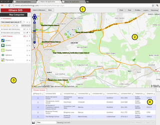
- Application Bar - where various functional elements are available
- Map window - this will maximize where it can see (Un-docked UI below)
- Layer control - docked or collapsible (elements previously in this area are now within Quick dialogs)
- Information Browser - docked or collapsible
The Interface - undocked
The interface from V5.0 has been designed to display more of the map with tools etc. displaying as drop down selections.
Here we can see the full map window (except for the Application Bar) which highlights how the Layer control and Information browser can be collapsed by the user.