Utilise ADS High DPI Output
Overview
While the official WMS specification does not define support for specifying the DPI (Dots Per Inch) of an image produced by a WMS (Web Map Service) various WMS servers such as GeoServer, MapServer and QGIS Server provide support via a vendor parameter. OS Premium Layers (colour and greyscale) now support passing any of the commonly used DPI vendor parameters. For example including any of the following in a WMS GetMap request would result in a DPI of 300:
DPI=300
MAP_RESOLUTION=300
FORMAT_OPTIONS=dpi:300
iShare GIS currently only produces output at 96 DPI
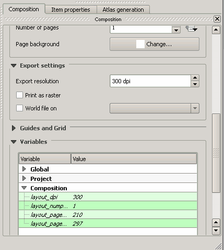
QGIS
In the QGIS Print Composer, the user should simply specify the Export resolution in the Print Composer window e.g.