MapInfo Professional WMS & WFS Examples
Open MapInfo Professional
WMS Table
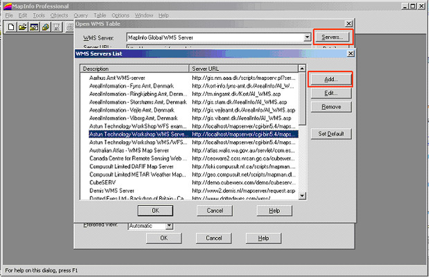
- Select to open a WMS Table and select a WMS Server from the dropdown list.
- If you cannot see the WMS Server in the list click on the Servers…. button to display the list of servers and click Add.. to add a new one.
- Select the WMS Layers that you wish to open from the list on the left and click Add>>
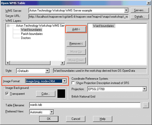
Note the additional Image Format that has come from MapServer (mode=24bit)
- Select the correct Coordinate Reference System Projection for British National Grid i.e. EPSG:27700.
- Edit the Table Filename to point to the location and filename you wish to create.
- Click OK.
Our Map Sources are WMS and WFS compatible but MapInfo has a tough time of connecting to them; our best guess is some sort of MapInfo patch. Anyhow, the trick is to create the WMS connection as normal and then modify the XML. The original XML file looked like this:
Original XML
<MI_WMS_MapDefinition version="1.0" wms_version="1.3.0"> <HTTP GetCapabilities="http://inspire.my_council.gov.uk/getows.ashx?mapsource=MyCouncil/Inspire" GetMap="http://inspire.my_council.gov.uk/getows.ashx?mapsource=MyCouncil/Inspire&"/> <Exception format="XML"/> <SRS>EPSG:27700</SRS> <Image bgcolor="16777215" transparent="true" format="image/png"/> <Layer><Name>Overlays</Name><Style></Style><LatLonBoundingBox minx="-180" miny="-90" maxx="180" maxy="90"/><BoundingBox SRS="EPSG:27700" minx="410000" miny="180000" maxx="500000" maxy="210000"/> </Layer> </MI_WMS_MapDefinition>
The new one looks like this:
Updated XML
<MI_WMS_MapDefinition version="1.0" wms_version="1.3.0">
<HTTP GetCapabilities="http://inspire.my_council.gov.uk/getows.ashx?mapsource=MyCouncil/Inspire&SERVICE=WMS" GetMap="http://inspire.my_council.gov.uk/getows.ashx?mapsource=MyCouncil/Inspire&SERVICE=WMS"/>
<SRS>EPSG:27700</SRS>
<Image bgcolor="16777215" transparent="true" format="image/png"/>
<Layer><Name>Overlays</Name><Style></Style><LatLonBoundingBox minx="-180" miny="-90" maxx="180" maxy="90"/><BoundingBox SRS="EPSG:27700" minx="410000" miny="180000" maxx="500000" maxy="210000"/>
</Layer>
</MI_WMS_MapDefinition>
As you can see we have added SERVICE=WMS to the two URLs and removed the Exception format line.
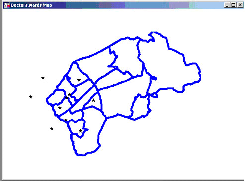
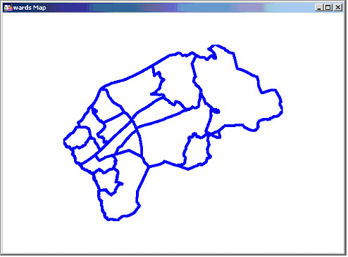
Example
WFS Table

- Select to open a WFS Table and select a WFS Server from the dropdown list.
- If you cannot see the WFS Server in the list click on the Servers…. button to display the list of servers and click Add.. to add a new one.
- Select the WFS Layer from the list and apply Data Filters such as Column Filter or Row Filter and Object Styles etc. as required.
- Select the correct Coordinate Reference System Projection for British National Grid i.e. EPSG:27700.
- Edit the Table Filename to point to the location and filename you wish to create.
- Click OK when done.
Example