Click on the Map Source  icon for a MyMaps Map Source and select the MapSource tab to enter the main options.
...
If you have move than one Map Source then you may use the Explorer Context menu to Set as Default MapSource. The default will be underlined in the Explorer.
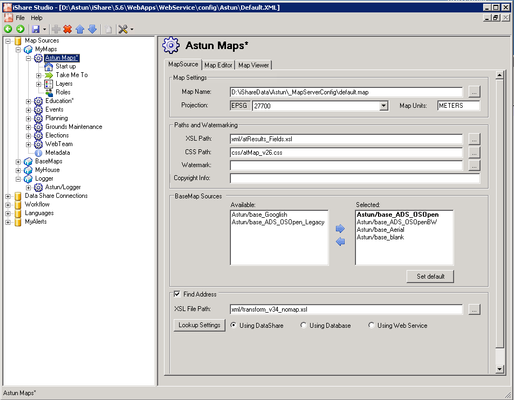
Map Settings
Map Name
This should be the full path to the MapServer .map file.
Projection
From Version 5.6.2. You may select a Projection for your Map Source by picking an entry from the list. There is a default Projection that is configured via the iShare Settings on the General tab under the Web heading.
.MAP files are currently configured to use the Projections provided by MapServer which include an extremely long list of SRID without descriptions. Astun now provide a cut down projections file which may be used. Please see Configuring Projections for details.
Map Units
From Version 5.6.2. The general Map Units for the Projection selected for the Map Source normally METERS or DEGREES (DEGREES are converted to DD). MapServer uses this for scalebar and scale computations. Valid options are [dd|feet|inches|kilometers|meters|miles|nauticalmiles] Nauticalmiles was added in MapServer 5.6. This setting replaces the 'Zoom Units' previously found in the MapSource Startup settings.
Paths and Watermarking
XSL Path
This defines the XML style sheet used in the translation from XML to HTML. This style sheet refers to either the Results panel or the My House page depending upon the type of use for the Map Source being defined. This should define the relative path from the root server site including.
CSS Path
This defines the cascading style sheet used in this theme. This should define the relative path from the root server site including filename and.
Watermark
This defines the watermark file. This should define the relative path from the root server site including filename and extension.
Copyright Info
The Copyright statement that will appear in the map.
...