Once you have downloaded and manipulated the CMIS data and updated the .MAP file you will be able to add your Councillors Classic Layer via iShare Studio.
- Expand the MyHouse Map Source and display the existing Layers
- If you don't already have a Layer Group that you wish to place your Councillors Layer under then you can create one - we have used Council and Democracy.
- Now create the Classic Layer for the Councillor Ward.
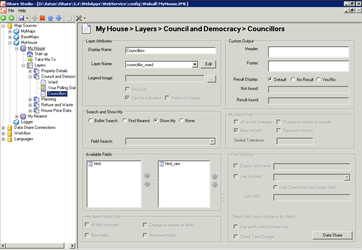
Layer Attributes
Display name
This will be displayed on the layers panel within My House e.g. Councillors.
Layer name
Select the corresponding map file layer from the drop down list, e.g. councillor_ward.
Search and Show My
Select the Show My radio button as this will perform a point in polygon search on the Layer e.g. Show my Councillor.
Available Fields
Select the html_raw field from the list.