Common Customer FAQs on INSPIRE & Enterprise Metadata
- Jo Cook (Deactivated)
- Elena Robu
- Kim Stimpson
Q: What is Metadata?
A: Metadata is information about data. Metadata records document the who, what, when, where, how, and why of a data resource. Geospatial metadata describes maps, Geographic Information Systems (GIS) files, imagery, and other location-based data resources. Non-spatial metadata can describe any other form of information, like spreadsheets, pdfs, videos, powerpoint presentations, and so on. As an analogy- imagine lots of tins of food without labels. How do you know what's in it, what the best before date is, who made it, and whether it's fit to eat?
Q: What is INSPIRE?
A: The INSPIRE Directive came into force in 2009 and aims to enable the sharing of environmental data among public sector organisations, and facilitate better public access to the same data. The UK Government mandated that all local authorities publish spatial data under the INSPIRE framework, for particular "themes", and with three phases:
- Make data discoverable by creating INSPIRE-compliant metadata and publishing through a data discovery service. In the UK this means using the Gemini 2.3 metadata standard and publishing through data.gov.uk
- Publish data through INSPIRE-compliant web services to allow the viewing and downloading of data. In general this means using a Web Map Service (WMS) for viewing and a Web Feature Service (WFS) for downloading.
- Transform data to comply with INSPIRE data specifications. In the UK this phase has not yet been enacted.
- Despite Brexit, this legislation is still in force!
See the attached pdf "A guide to INSPIRE compliance in local government" for further information.
Q: What is Gemini?
A: Gemini is the UK implementation of the INSPIRE metadata standard. It describes the information that is required for a metadata record to be compliant with INSPIRE and to be accepted for publication to data.gov.uk. The current version of Gemini (as of October 2018) is 2.3, and since December 2019 all records published on data.gov.uk must be compliant with Gemini 2.3. For more information about Gemini please visit the official documentation at https://www.agi.org.uk/agi-groups/standards-committee/uk-gemini.
Q: What is 'Get INSPIREd'?
A: Get INSPIREd is an initiative by Astun Technology to allow existing and new customers to create publicly accessible metadata such as for harvesting onto data.gov.uk, compliant with both the INSPIRE directive and Gemini 2.3. It is a cost-effective and easy to use implementation that can be integrated with existing workflows or be completely stand-alone. Get INSPIREd is entirely cloud-hosted by Astun, so you don't have to worry about getting software installed on your servers, or keeping it up to date with new releases.
Q: Do I need to have iShare?
A: You don't need to have iShare for 'Get INSPIREd', as you can have access to the metadata catalog for creating and publishing records without iShare in place. However, without iShare you will miss out on the awesome functionality of integrating metadata with your internet and intranet mapping!
Q: What's the difference between INSPIRE and Enterprise Metadata?
A: INSPIRE metadata is metadata published to data.gov.uk, generally for the purposes of meeting the requirements of the INSPIRE directive. All INSPIRE metadata records are publicly accessible via a GeoNetwork catalog portal, with a dedicated CSW (Catalog Service for the Web) endpoint. Enterprise metadata is any metadata that you wish to store for other business purposes. You may not want this to be publicly accessible, in fact you may not even want it to be accessible by everyone in your organisation, so with Enterprise you get a GeoNetwork portal and a second CSW endpoint restricted just to your organisation.
Enterprise metadata is not just restricted to spatial datasets- we support non-spatial as well (even for harvesting to data.gov.uk if you want!).
Q: What is a Metadata Catalog?
A: A metadata catalog, or store, or portal, is where metadata records are held. The data that the records refer to is held elsewhere, such as in a database. The catalog provides a searchable access point for your metadata, and a service endpoint (CSW) that can be used by external parties (such as data.gov.uk) to ingest or harvest your metadata.
Q: What is GeoNetwork?
A: GeoNetwork is the leading open source metadata catalog. Astun Technology use GeoNetwork as the basis for the GetINSPIREd initiative and are committed to maintaining the plugins to use Gemini 2.3 in GeoNetwork.
Q: Can everyone see or change my metadata?
A: Only if you let them! Metadata records must be explicitly published to make them available to the outside world. INSPIRE records must be publicly accessible, but read-only. With Enterprise, you can also assign different privileges to records to make them visible to a select group of people, or to allow some people to edit them.
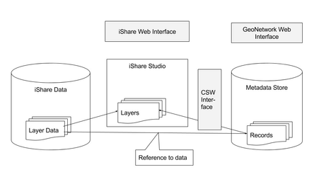
Q: Can I access metadata stored in a GeoNetwork metadata catalog in iShare GIS?
A: A layer in iShare GIS can be linked to it's corresponding metadata record in iShare Studio. Please see Metadata Overview for the information on the initial configuration of iShare Studio to link it to GeoNetwork, and then the method for linking metadata to a layer. Once the metadata is linked, then it is available for searching via the Omnisearch bar in iShare GIS, where it can also be used to add layers to your map. Metadata can also be accessed via the Info icon in the controls for an individual layer.
Q: Can I access metadata stored in a GeoNetwork metadata catalog in iShare Maps?
A: Yes, via the info Info in the controls for an individual layer.
Q: Are any metadata records stored in iShare GIS?
A: No metadata is stored in iShare GIS, just links to the records, so any updates made to the metadata in the catalog will be reflected in the metadata available in iShare GIS.
Q: What is a CSW Interface?
A: A Catalogue Service for the Web (CSW) interface or endpoint is a web service, much like a WFS or WMS, and is the method by which external parties such as data.gov.uk gain access to the metadata. Only metadata that has been explicitly published can be accessed by the CSW service.
Q: How can I link to metadata in QGIS?
A: With Enterprise you can use the CSW endpoint URL for your metadata catalog in the metasearch plugin in QGIS, giving you the capability of searching for, and adding data via the metadata catalog directly into QGIS.
Q: What format do my Metadata records need to be in?
A: The Metadata records in the catalog need to be in UK Gemini 2.3 format, however we can provide methods of transforming from other standards as an optional extra.
Q: Do I have to provide all my iShare GIS users with GeoNetwork logins?
A: No, a single user is configured in iShare Studio that is used to automatically sign iShare GIS users in. For access with different rights, such as an editor, you would indeed need to set up a new user with credentials in GeoNetwork.
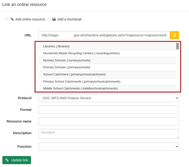
Q: How do I fix a broken WFS or WMS link in a metadata record?
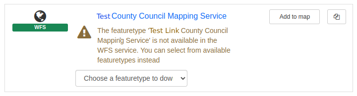
A: This often occurs when the WFS or WMS link for a record points to the service rather than to a specific layer. To fix, sign in to GeoNetwork and locate the record with the broken link. Once located, start an Editing session (by clicking on the ✎Edit button). On the right-hand side, find the broken link in the Resources section and edit it (also by clicking the ✎ button). In the pop-up window that opens, choose the correct Layer name from the dropdown list below the URL and click 🔗 Update link