iShare Solo
- Kim Stimpson
Overview
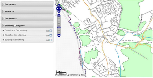
iShare Solo allows you to display interactive maps within any web page. It also has the ability to display various panels for functions such as Find Address, Find Nearest etc.
By default the map data that is displayed is that which you have defined as your Default MapSource in iShare Studio. The default start up map zoom level and positioning is controlled by your MyMaps Startup parameters as defined in iShare Studio. These settings may be configured so please click on one of the Example Code links below for details.
Please refer to one of the following pages, depending upon your version of iShare, for details on how to embed an Interactive Map with Panels into your web page:
Adding a Feature List to your iShare Solo map
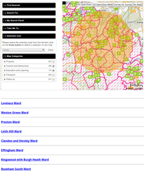
As with iShare Lite, iShare Solo may be configured to display an additional Feature List (links) for a pre-defined layer - available from v4.4.6. This list will only be displayed if the relevant layer has been selected. In the example below the Primary Schools layer has been defined as the layer whose entries are to be displayed in the Feature List and this layer has been selected in the Show Map Categories. Clicking on a link in the list will zoom to the feature on the map and display the information for the feature e.g.
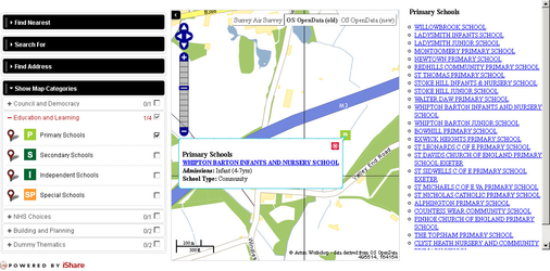
Here you can see the results of clicking on the link for Whipton Barton Junior School.
Please refer to one of the following pages, depending upon your version of iShare, for details on how to embed an Interactive Map with Panels and Feature List into your web page:
- Including a Feature List in iShare Solo - from v5.4.0
- Including a Feature List in iShare Solo - pre v5.4.0
Include points from a GeoRSS feed
As with iShare Lite, iShare Solo may be configured to display information from a GeoRSS feed. When you include a GeoRSS feed in the constructor for the map, it will fetch the data, add the points to the map, then zoom so that the map displays all of the data. Available from v5.2.6.
Please refer to one of the following pages, depending upon your version of iShare, for details on how to embed an Interactive Map with GeoRSS feed into your web page:
- Including a GeoRSS Feed in iShare Solo - from v5.4.0
- Including a GeoRSS Feed in iShare Solo - pre v5.4.0
Adding a Selection Panel
5.4.10+
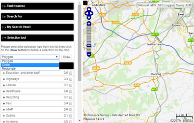
From v5.4.10 there is the ability to add a Selection tool panel to iShare Solo. This will allow the user to select an Area of Interest on the Map using a Polygon, Circle or Rectangle tool. First the type of tool is selected and then you click on the map to select the area. When the area has been selected the active layers will be queried and the results returned for display.
- First select the selection Type from the list and then click the Draw button.
- Now you draw your Area of Interest (AOI) on the map.
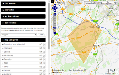
- When you have finished drawing your AOI the results will be displayed.
- Then you can click the Clear button to remove your AOI.
Please refer to the following page for details on how to add a Selection tool panel:
Hiding the Map Categories panel on loading your Solo Map
5.4.10+
By using a simple plugin you can change the way that your Solo Map loads. By default the Map Categories panel is displayed along with your map. If you configure this plugin then, when you open your Solo Map the Map Categories panel will show for a second, just to let the user know that it exists, and then slide away to the left.
Please refer to the following page for details on how to create and configure the CloseMapCategoriesOnLoad plugin.