BaseMaps Details
- Kim Stimpson
- Matt Walker
Click on the Details  node under your BaseMaps entry.
iShare v6.0.0 uses MapProxy to serve up the Base Mapping and allows you to connect to a WMTS (Web Map Tile Service) as well as a WMS (Web Map Service).
The WMTS Tile resource represents a single cached tile. You can request WMTS tiles in both RESTful and Key-Value Pairs (KVP) syntax as defined by the OGC WMTS specification. As compared to the WMS, the main advantage of the WMTS is that it offers better performances in the publishing of cartographic data, as the tiles are stored in a cache at the time of the first generation. On the other hand, the WMTS is not recommended when the data are updated frequently, since it then means the cache has to be invalidated for the data to be brought up to date.
MapProxy is a Python application which can not only cache WMS feeds, but allow us to convert between feed types, for example, WMTS to WMS and vice versa.
| WMTS | WMS |
|---|---|
|
|
For details on how to configure Legacy Base Mapping, which is not supported in iShare v6.0.0, please see BaseMap Details (Legacy).
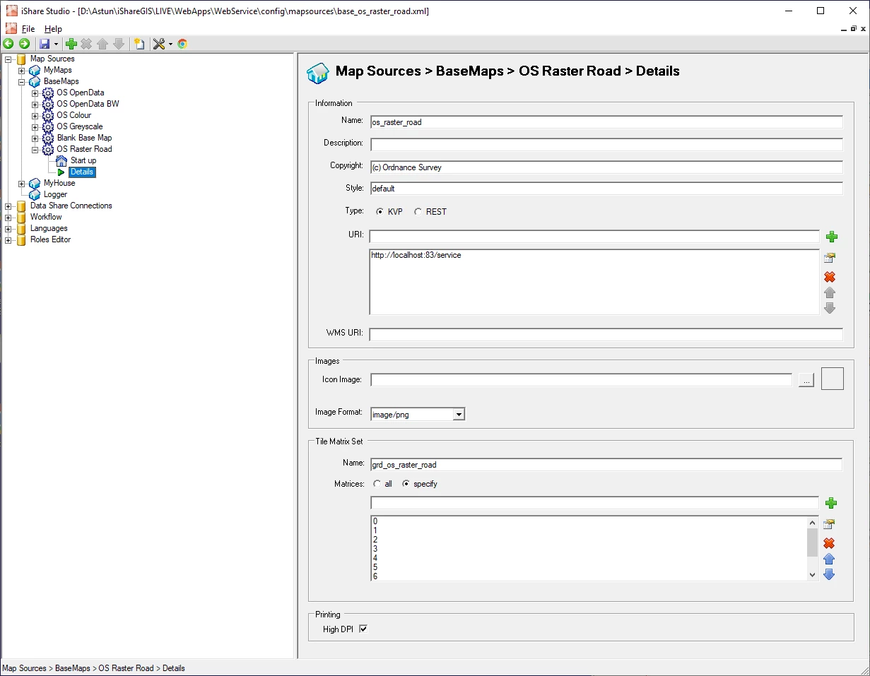
Information
Name
This is the name of the WMS or WMTS layer in the mapproxy.yaml.
From v5.2.2 - If you are using Astun Data Services - ADS v1 mapping then entering any of the following will automatically assume that this is an ADS map layer and use the appropriate type of tile requests (i.e. WMS and not TileCache):
- osopen - OS OpenData Maps
- osopenbw - OS OpenData Maps in Black & White
- ospremium - OS Premium - requires an OS Licence
- ospremiumbw - OS Premium in Black & White- requires an OS Licence
To assume ADS mapping the name must be entered exactly as highlighted above.
Description
Only used within the Studio to identify the purpose of the BaseMap.
Copyright
The Copyright statement written to the map panel.
Prior to V5.6.2 - do NOT include the copyright symbol "@" in your text here as it causes issues in iShare.
Style
WMTS only
Allows the client to specify a style which is listed in the GetCapabilities for the layer, but generally should be left as default.
Type
WMTS only
Defines how iShare should request the tiles from the server, either as key-value pair (KVP) or restful. Generally should be left as KVP.
URI
This is the URI to the service to which iShare requests the BaseMap images.
The main box is used for editing your URI. Type in the box provided and click on the Green plus to Add a new entry. To change an existing entry select it from the larger list box and either double click on it or click the Edit icon. To Delete an entry, select it and click on the Red cross or move entries up and down the list by selecting them and using the Up and Down arrows.
WMS URI
WMTS only
This is required for HiDPI Printing. If your BaseMap is WMTS then this can be the same as the URI, if not then you need to enter the URL to your MapProxy.
Images
Icon Image
This is not used at present.
Watermark
This is the watermark that is superimposed on the tile whilst they are being generated.
Image Format
Format of the generate tiles.
Tile Matrix Set
WMTS only
Name
This the name for the MapProxy Cache in the mapproxy.yaml file.
Matrices
Select the Specify radio button then, type in the box provided and click on the Green plus to Add a new entry. To change an existing entry select it from the larger list box and either double click on it or click the Edit icon. To Delete an entry, select it and click on the Red cross or move entries up and down the list by selecting them and using the Up and Down arrows.
Scales
WMS only
This is where you define the number of zoom scales that you require. This will define how many bars you see on the Navigation tool on the map and also how the tile cache is generated. This would normally be populated by your Astun Consultant.
Scale / Resolution Relationship
To convert from RESOLUTION to SCALE use the following formula:
SCALE = RESOLUTION / (2.54 / (72 * 100))
Where 2.54 is CM per Inch and 72 is the DPI.
For example:
4535433.071 = 1600 / (2.54 / (72 * 100))
To convert from SCALE to RESOLUTION use the following formula:
RESOLUTION = SCALE * (2.54 / (72 * 100))
For example:
1600 = 4535433.071 * (2.54 / (72 * 100))
You should be able to use the formulae above in a spreadsheet, for example assuming you have a resolution value in cell A1 entering the following formula in cell B1 will calculate the corresponding scale:
=A1 / (2.54 / (72 * 100))
Printing
5.8.8+
High DPI
If you wish to use the HiDPI Print functionality in iShare GIS and your BaseMap supports High DPI then you should tick this box. This can be deselected for those BaseMaps which have not been configured for use with High DPIs.
If the BaseMapping service doesn't support a DPI or MAP_RESOLUTION parameter, PDFs generated using it may exhibit unexpected style behaviour if this is left enabled.