BaseMaps Options
- Kim Stimpson
Click on the Map Source  icon for a BaseMaps Map Source and select the MapSource tab to enter the main options.
You can Edit and View the BaseMap using the Map Editor and Map Viewer tabs respectively.
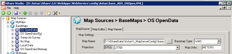
Map Settings
Map Name
Click on the Browse button beside the Map Name entry and select the Basemap_nnnn.map file that you wish to use for this entry.
Basemap Type
Here you can select your BaseMap type from the drop down list box. This can either be WMS if you are using ADS BaseMaps which uses WMS or Legacy for normal BaseMaps i.e. using a Tile cache.
From iShare 6.0.0. the options will be WMS or WMTS (Web Map Tile Service) and the maps will be served using MapProxy (which does not support Tilecache so Legacy will no longer be supported).
Projection
From Version 5.6.2. You may select a Projection for your Map Source by picking an entry from the list. There is a default Projection that is configured via the iShare Settings on the General tab under the Web heading.
.MAP files are currently configured to use the Projections provided by MapServer which include an extremely long list of SRID without descriptions. Astun now provide a cut down projections file which may be used. Please see Configuring Projections for details.
Map Units
From Version 5.6.2. The general Map Units for the Projection selected for the Map Source normally METERS or DEGREES (DEGREES are converted to DD). MapServer uses this for scalebar and scale computations. Valid options are [dd|feet|inches|kilometers|meters|miles|nauticalmiles] Nauticalmiles was added in MapServer 5.6. This setting replaces the 'Zoom Units' previously found in the MapSource Startup settings.
Tile Cache
This only appears if your Basemap Type is Legacy.
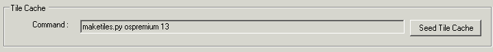
Command
This is the command used to create your tile cache and should only be changed by an Astun consultant.
Seed Tile Cache
This button will run the procedure to create your Tile Cache and, depending upon your setup, could take some time.