GIAS / EduBase
| System Category | Education |
|---|---|
| Source | Syndicated by Astun Data Services |
| Available since | 2013 |
| Organisation |
|

Introduction
There a new service from GOV.UK called Get information about schools (GIAS), which replaces the EduBase service for educational professionals in England. The service supplies a register of educational establishments in England and Wales, maintained by the Department for Education. It provides information on establishments providing compulsory, higher and further education.
Important
Please note that it is not currently possible to classify Welsh schools by type of establishment as this information is no longer provided in the GOV.UK service
The Astun Data Services (ADS) EduBase Downloader essentially acts as a central repository for the Educational establishments data for England & Wales and, as the structure of the data has not changed, neither has this service. This links seamlessly with the iShare platform allowing educational information to be displayed on map layers.
Note: The ADS EduBase Downloader is only available to customers on iShare v4.4.6 or greater as it requires OGR 1.8 to connect to the WFS connection.
Why ADS?
- ADS requests all data for England once a day, so ADS is always in sync with GOV.UK
- ‘One stop shop’ for all authorities using the iShare platform
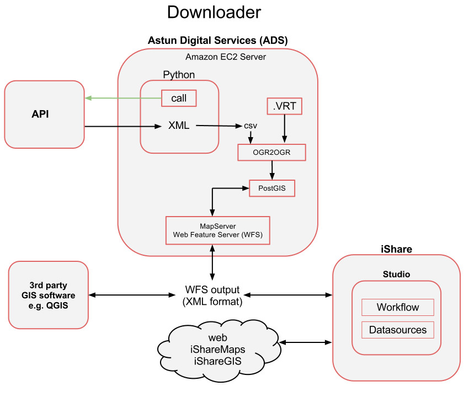
- ADS Python script makes a call to the GIAS service for data. Rather than creating a localised search and restricting the results the script asks for all data, returning all data for England.
- The service returns data in XML format, which is converted into a csv file.
- The csv is then processed by the OGR2OGR program which converts the data into a suitable format and inserts the data into a PostGIS database (spatially enabled PostgreSQL). The .VRT file effectively acts as ‘style sheet’ for OGR2OGR’s import of the csv file (which file to import, coordinate system (lat, lng).)
- The MapServer Web Feature Service (WFS) retrieves data from PostGIS (as a result of iShare or 3rd party GIS software user requests) and provides an XML/ GML output.
- iShare Maps and iShare GIS Studio administrators request the latest data from the MapServer WFS. The iShare Maps and iShare GIS Studio facilities allow the GIAS data to be displayed, as individual layers, on customer facing websites and internal intranet systems.
- The GIAS data can be displayed using other 3rd party GIS software, such as Quantum GIS (QGIS) - see WFS Client Connection Examples for details.
Configuring the Workflow in Studio
The following steps outline how you can download the GIAS data and keep it up-to-date.
- Create a Workflow Connection to the EduBase WFS feed provided by the Astun Data Services (ADS)
- Create a Job to Refresh the EduBase data
- Create Task to download EduBase data
- Create Task to Create Table for Nursery Schools and any other types of School you wish to display. Our example uses Nursery Schools but you may change this for any type you like. If you wish to use the Standard Layer type (OGC Layers) then it is much easier to first create individual tables to filter out the data before you create the Layer.
Using Standard Layers
If you are using the Standard Layer type of OGC Layers then all you need to do now is to Configure your individual EduBase Layers in Studio.
Using Classic Layers
If you are using Classic Layers, required for My House / My Nearest, then you will first need to update your .MAP file to include these new EduBase layers. See Update .MAP file for EduBase Classic Layers for details. Once the .MAP file has been updated you will be able to configure the EduBase Classic Layers via iShare Studio.