Annotation Layers
- Kim Stimpson
Sometimes referred to as ‘red lining’, this functionality enables users to annotate a map with lines, polygons, points and text. The annotations are stored by iShare GIS and are displayed in their own layer over the top of all others. This annotation layer is persistent, if the user loads iShare GIS at a different time or in a different browser then all annotation previously created will be visible.
Layer annotations require a user be authenticated. This is so that the annotation can be stored by the iShare GIS back-end against the user's authenticated name. Annotations are not stored in cookies and if the user is unauthenticated (i.e. the web application is being used anonymously) then the annotations will not be available.
Users can create different ‘Annotation Maps’ and either keep them private or share them with other users.
Any Annotation layers that you have created or to which you have been given permission will be displayed in the Map Categories (or Layer Control).
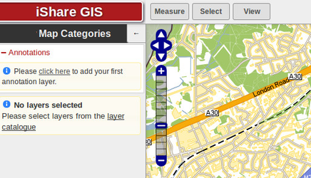
If you have not created any Annotation layers, or none have been shared for your use, then there will be a message with a link to adding your first layer as shown in the screenshot. |
|
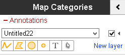
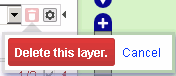
This is the same as clicking on the New layer link which simply adds a new Untitlednnn layer where nnn is a sequential number. If you wish to pick an exiting Annotation layer use the dropdown arrow to select one from the list. The Show / Hide Layer button The Actions button Prior to v5.6.0 Delete |
|
First click on the Properties button If you select to add a New Layer then the Properties will be automatically displayed. Please see the Styling your Annotation Layer topic for further details. |
|
Once you have setup the defaults for your new Annotation layer you can begin to add the required features. See the topic Adding a new Annotation Feature for details. |
|