/
Import Layers with different Projections
Import Layers with different Projections
- Kim Stimpson
Owned by Kim Stimpson
Last updated: 06 Aug, 2020
iShare requires it's maps to be in British National Grid but you may have files created with a different co-ordinate system such as Lat/Long. If you are unsure of the projection of your file then please see Find the Projection of a Shape file for details.
Using a Workflow Spatial Data Transformation in Studio it is possible to convert your Layer to British National Grid (EPSG:27700).
- Open Studio.
- Expand the Workflow node
- Expand the Jobs node and right click on Unassigned Tasks node and select New Task.
- Pick Spatial Data Transformation from the list and click OK.
- Enter a unique Name for your Task.
- Select your Source Data and Output. In our example screenshot below our input is a Shape file and we are outputting to the Data Share database.
- Under the Options UNTICK Projection as British National Grid
- Tick Expert mode
- Now in the Additional Parameters box add the following:
-s_srs EPSG:4326 -t_srs EPSG:27700
where EPSG:4326 is Lat/Long and EPSG:27700 is British National Grid.
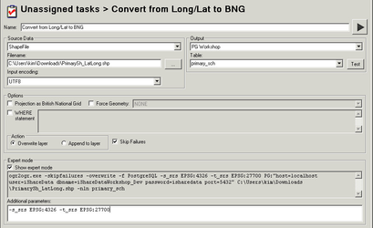
You can either just click the Play button  to convert your data or click Save and either run manually or add this to a Workflow Job.
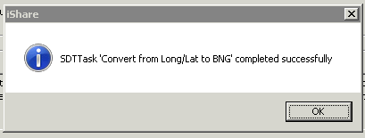
You should see a successful message when you run the task e.g.
, multiple selections available,
Related content
iShare Studio ETL
iShare Studio ETL
More like this
Implement SSO for iShare GIS with Azure ID (Microsoft Entra ID)
Implement SSO for iShare GIS with Azure ID (Microsoft Entra ID)
Read with this